Over 100 cemeteries have been located and mapped in McDonough County. Click the pdf link below to view the full-size map. The map and GPS coordinate list is also available for purchase at our Center.
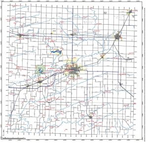
McDonough County Cemetery Map (pdf)
Cemeteries by GPS Location
| Name of Cemetery | AKA | Township | Latitude | Longitude |
|---|---|---|---|---|
| Almshouse Cemetery | County Farm | Scotland | 40.431415 | -90.662076 |
| Almshouse Site | Scotland | 40.433069 | -90.65682 | |
| Anderson | Huff | Blandinsville | 40.554576 | -90.815955 |
| Arberghast-Pearce | Scottsburg | Walnut Grove | 40.565251 | -90.597508 |
| Archer Bethel | Sullivan, West Bethel | Bethel | 40.34752 | -90.75623 |
| Argyle | Hire | 40.463102 | -90.806519 | |
| Atkinson/McCord | Emmet | 40.46685 | -90.781873 | |
| Bailey | Chalmers | 40.426135 | -90.69552 | |
| Banks | Hire | 40.483422 | -90.896525 | |
| Barber | Colchester | 40.405 | -90.77278 | |
| Bardolph | Macomb | 40.49806 | -90.56944 | |
| Bean | Colchester | 40.437166 | -90.773091 | |
| Beckelshymer | Sciota | 40.590611 | -90.721825 | |
| Bowlin-Wayland | Ridon | Chalmers | 40.376484 | -90.728771 |
| Bushnell | Bushnell | 40.547261 | -90.493184 | |
| Camp Creek | Industry | 40.36684 | -90.647022 | |
| Central | Rock Creek | Hire | 40.497719 | -90.895109 |
| Chockley | Eldorado | 40.29671 | -90.531794 | |
| Clark-Evans-Woods | New Salem | 40.44488 | -90.495835 | |
| Clayton | Clugston | Industry | 40.2995 | -90.634306 |
| Craig | Scotland | 40.370981 | -90.610976 | |
| Dailey | Moore | Eldorado | 40.360618 | -90.557875 |
| Doddsville | Industry | 40.285639 | -90.650285 | |
| Duncan | Blandinsville | 40.550733 | -90.900516 | |
| Dunkard | Bethel | 40.32893 | -90.782912 | |
| Dunsworth | Bethel | 40.352825 | -90.774299 | |
| Dye/Pope | Tennessee | 40.450851 | -90.901395 | |
| Forrest Lawn Memorial Garden | Chalmers | 40.452506 | -90.71922 | |
| Foster Point | Eldorado | 40.358124 | -90.468761 | |
| Friendship with Mouring Sec. | Tennessee | 40.460278 | -90.881572 | |
| Gibson Cemetery | Fandon | Bethel | 40.366939 | -90.774999 |
| Glade City | North Cemetery | Blandinsville | 40.55778 | -90.86444 |
| Good Hope | Walnut Grove | 40.565603 | -90.671519 | |
| Guy | Emmet | 40.500554 | -90.757232 | |
| Hainline - Sec of Spring Creek | Emmet | 40.5378389 | -90.7543694 | |
| Hamilton | Walnut Grove | Walnut Grove | 40.544906 | -90.64159 |
| Harris | Eldorado | 40.363516 | -90.449185 | |
| Hays | Hire | 40.546449 | -90.835767 | |
| Head Graveyard | Emmet | 40.543653 | -90.771103 | |
| Hickory Grove | Sorghum Grove | Walnut Grove | 40.605317 | -90.637278 |
| Hills Grove | Tennessee | 40.386283 | -90.890431 | |
| Hillsborough | Blandinsville | 40.600816 | -90.885578 | |
| Hutchinson | Oakridge | Tennessee | 40.375617 | -90.828528 |
| Industry City | Industry | 40.332205 | -90.604502 | |
| Jacoby | Emmet | 40.510844 | -90.70082 | |
| King | Tabler | Lamoine | 40.363785 | -90.859564 |
| Larkins | Walnut Grove | 40.630724 | -90.608403 | |
| Liberty | Blandinsville | 40.579555 | -90.860222 | |
| Lower | Colchester | 40.398768 | -90.815815 | |
| Lynn-Hageman | Lynn Grove, Lynn Center, Lantz | Walnut Grove | 40.585995 | -90.588215 |
| Martha Miler Gravesite | Chalmers | 40.370405 | -90.766689 | |
| Miles | Eldorado | 40.314421 | -90.474252 | |
| Monger | Sciota | 40.564925 | -90.718085 | |
| Mound Chapel | Lizden, Mound Methodist | Mound | 40.491337 | -90.504316 |
| Mount Auburn | Colchester | 40.434363 | -90.798367 | |
| Murray | Chalmers | 40.422408 | -90.751543 | |
| Mustain | Blandinsville | 40.602793 | -90.863769 | |
| Neece | Colchester | 40.39737 | -90.789913 | |
| New Hope/Old South | Bapist, Foster | Hire | 40.541706 | -90.865989 |
| Oakwood | Macomb City | 40.47083 | -90.668609 | |
| Old Bedford | Barnes | Blandinsville | 40.638491 | -90.893922 |
| Old Macomb Catholic | Chalmers | 40.455328 | -90.714195 | |
| Old Macomb or McDonough Co. | Macomb City | 40.46389 | -90.695559 | |
| Old Plymouth | Whittington | Lamoine | 40.300909 | -90.902909 |
| Old Prairie City | Prairie City | 40.628378 | -90.456632 | |
| Osborn | Clayburgh | Industry | 40.315097 | -90.618254 |
| Peak | Industry | 40.315226 | -90.596676 | |
| Pennington | Coker | Industry | 40.330043 | -90.64235 |
| Pennington Point | New Salem | 40.396431 | -90.555417 | |
| Peterson Gravesite | Colchester | 40.447976 | -90.782579 | |
| Pioneer | Bethel | 40.319129 | -90.732686 | |
| Post/Shippey/Dew | Emmet | 40.459041 | -90.765607 | |
| Prairie City | Prairie City | 40.627616 | -90.471689 | |
| Primitive Baptist | Bethel Baptist | Bethel | 40.339343 | -90.731558 |
| Pruett | Bethel | 40.29671 | -90.729848 | |
| Rigg | Bethel | 40.356996 | -90.694176 | |
| Sacred Heart | Old Roman Catholic (Tennessee) | Tennessee | 40.427136 | -90.844492 |
| Scott's | Bethel | 40.299242 | -90.792155 | |
| Simmons | Macomb City | 40.514482 | -90.743712 | |
| Simpson | Shannon | Macomb City | 40.490308 | -90.672004 |
| Spring Creek | Spring Grove, Sciota, Humbert, Russell | Emmet | 40.537838 | -90.75437 |
| Springer Grave Site | Industry | 40.300447 | -90.592469 | |
| St. Paul Catholic | Macomb City | 40.47111 | -90.67278 | |
| Standard | Industry | 40.308867 | -90.577561 | |
| Stevens | Chalmers | 40.412381 | -90.756662 | |
| Stickle | Macomb City | 40.51609 | -90.710381 | |
| Stoneking | Bethel | 40.299024 | -90.744687 | |
| Stoneking 2 | Bethel | 40.298844 | -90.745025 | |
| Strader-Nankivel | Chalmers | 40.376914 | -90.731841 | |
| Unitarian Cemetery | Macomb City | 40.461122 | -90.695378 | |
| Upper Mound | Mound United Brethren, High Mound, Dyer, Sheets | Mound | 40.503909 | -90.466749 |
| Vail | Industry | 40.327263 | -90.599516 | |
| Vance | Industry | 40.32165 | -90.579007 | |
| Vawter | Bethel | 40.334412 | -90.706997 | |
| Walker | Emmet | 40.523501 | -90.770488 | |
| Waymack | Bethel | 40.348819 | -90.751541 | |
| Wesley Chapel | Blandinsville | 40.595942 | -90.904895 | |
| White | Tennessee | 40.441367 | -90.85666 | |
| White Flock | Lewis, Rice, Jenkins, Bayles, Payne | Lamoine | 40.353803 | -90.829895 |
| Widow Moore | Old Colchester | Colchester | 40.426205 | -90.810527 |
| Widow Taise | Tennessee | 40.45659 | -90.863047 | |
| Wilhelm | Industry | 40.315092 | -90.595486 | |
| Willey | Bethel | 40.288752 | -90.700234 | |
| Wilson | Blandinsville | 40.586174 | -90.883722 |